
An AI Vehicle in Abu Dhabi Can Spot Road Problems Before Someone Reports Them
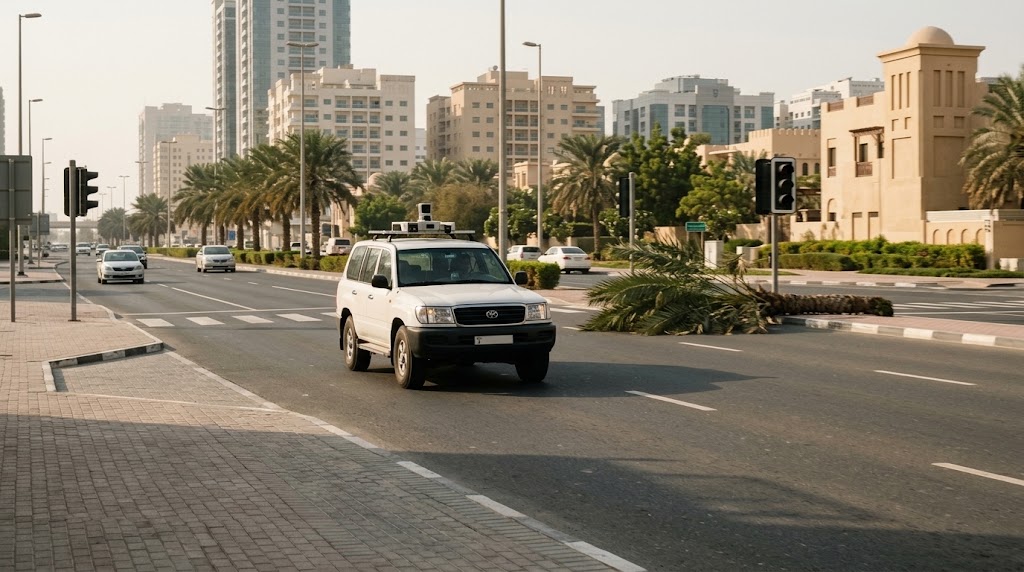
The UAE AI Alliance is developing vCity, an AI-equipped vehicle that moves through Abu Dhabi detecting fallen trees, broken traffic signals, road obstacles and even accidents that may not yet have been reported. The concept turns an ordinary road journey into a moving municipal inspection, although deployment scale and detection accuracy remain undisclosed.
Arabian Current
What happened
vCity adds a mobile AI sensing layer capable of detecting and locating issues as a vehicle moves through the road network.
Why it matters
The vCity project uses an AI-equipped vehicle to detect road hazards and infrastructure problems while travelling through Abu Dhabi, but its deployment scale, coverage and detection performance have not been publicly disclosed.
The announcement does not disclose the number of vehicles, geographic coverage, technical architecture, accuracy, retention practices or quantified operational outcomes.
The vCity project uses an AI-equipped vehicle to detect road hazards and infrastructure problems while travelling through Abu Dhabi, but its deployment scale, coverage and detection performance have not been publicly disclosed.
A road problem normally has to be seen before it can be fixed.
Often that means someone notices it, reports it and waits for the information to reach the right authority.
Abu Dhabi's vCity project is experimenting with a different sequence.
An AI-equipped vehicle can identify problems while travelling through the city and send their location and condition to the relevant authorities.
The vehicle is looking for things that should not be there
The UAE AI Alliance says vCity can identify fallen trees on roads, traffic accidents that have not yet been reported, malfunctioning traffic signals and other obstacles that may disrupt movement or affect road safety.
The vehicle captures the situation and its location while moving through different areas of Abu Dhabi.
That turns road monitoring into a continuous field-data exercise rather than one dependent only on fixed sensors or incoming reports.
Finding the problem is only the first half
The project is designed to send the captured information to the relevant government entities.
Authorities can then locate the issue and decide what action is required.
The AI therefore does not repair the traffic signal, remove the fallen tree or investigate the crash.
Its role is detection, localisation and faster information flow.
An unreported accident is the most interesting use case
Fixed traffic systems can monitor known intersections and road segments.
Public reports depend on someone choosing or being able to report an incident.
A mobile detection system creates a third source of information: the city itself being observed as a vehicle moves through it.
That could be especially useful for events that occur outside fixed monitoring points or before emergency and transport systems receive a report.
The public evidence does not tell us the scale
WAM describes vCity as a project being developed and implemented for government use.
The announcement does not disclose how many vehicles are operating, which Abu Dhabi districts are covered, how frequently roads are scanned or whether the system runs continuously.
It also does not publish detection accuracy or false-positive rates.
A vehicle being able to detect a problem is therefore different from proving the city is already comprehensively monitored this way.
The customer may never know the technology was involved
Unlike a robotaxi or smart gate, residents may never interact directly with vCity.
Its effect is experienced indirectly.
A blocked lane may be cleared sooner.
A faulty signal may reach a maintenance team faster.
A road incident may enter the response system without waiting for a phone call.
That still makes it experiential technology because the outcome changes the physical experience of moving through the city.
Mobile sensing creates its own questions
A system that continuously observes public roads needs clear operating boundaries around what is captured, retained and transmitted.
The public announcement focuses on road conditions and safety hazards and does not describe broader data collection.
More technical disclosure would help establish how the system distinguishes useful road intelligence from unnecessary surrounding information.
What Arabian Current is watching
Watch fleet size, geographic coverage, response-time improvements, detection accuracy and whether authorities publish evidence showing that vCity finds incidents before conventional reporting channels do.
The strongest result would be a measurable reduction in the time between a road problem appearing and the city knowing it exists.
Road authorities could rely on fixed monitoring systems, inspections and public reporting to identify many field problems.
vCity adds a mobile AI sensing layer capable of detecting and locating issues as a vehicle moves through the road network.
The next evidence should show operating scale, detection accuracy and whether the system materially shortens government response times.
Show the record behind the claim.
Claims stay source-linked, with limits recorded.
WAM reports that vCity uses an AI-equipped vehicle to identify fallen trees, unreported accidents, faulty traffic signals and other road obstacles and relay that information to relevant authorities.
Material reporting is designed to retain the evidence behind the published claim.
Companies, regulators and projects can link back to persistent records.
Automation can assist discovery and extraction; publication authority remains editorial.
Open the evidence record.
1 linked sourceSupport + limitations recorded.
01Core evidencevCity project uses smart vehicles to monitor road challenges in Abu Dhabi
Emirates News Agency
+
vCity project uses smart vehicles to monitor road challenges in Abu Dhabi
Emirates News Agency
Confirms the AI-equipped vehicle, hazard categories, unreported-accident detection and relay of information to relevant government authorities.
Does not disclose operating scale, coverage, accuracy or quantified response-time improvements.
The story keeps moving.
Track fleet size, districts covered, operating hours, false-positive rates, incident-detection lead time and measurable response improvements.

Reporting with a visible evidence trail.
Arabian Current reporting is built around human editorial authority, source-linked claims and visible evidence trails.